Beyond The Laugavegur
Basic info
Type: Solo long-distance hike
Location: South Iceland
Start – End: Skógar – Rjúpnavellir
Lenght: aprox. 250-300km
When: September 2026
Duration: 11 days
Transportation: Hiking
Support: Solo supported, tent based
Terrain: volcanic deserts, highland valleys, geothermal areas, river crossings
Introduction
In September 2026, I am planning an extended solo trek through the Icelandic Highlands, connecting the classic Laugavegur route with Hellismannaleið.
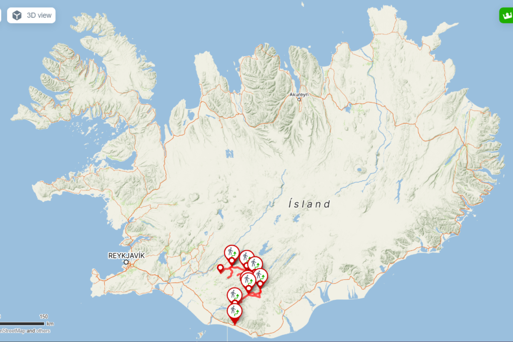
The route will cover approximately 250–300 kilometres over around 11 days, starting at Skógar and continuing through Þórsmörk, Landmannalaugar and ending in Rjúpnavellir.
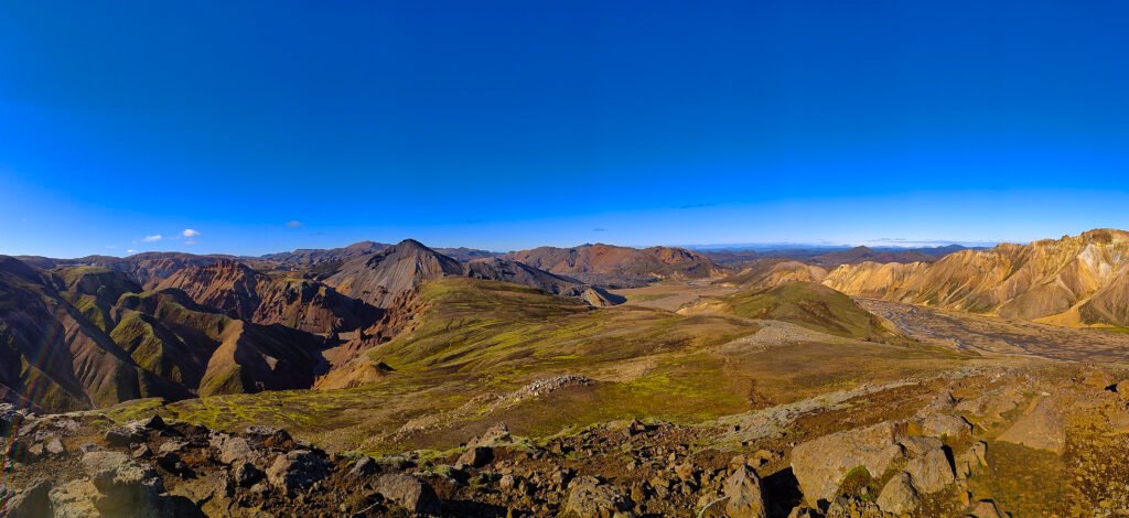
I have already travelled through many parts of Iceland by car, but this journey is meant to be different. Instead of moving between individual locations, I want to experience the Highlands as one continuous landscape — crossing volcanic deserts, geothermal areas, glacial rivers and remote valleys entirely on foot.
For me, this expedition is another step toward longer and more independent journeys in remote environments — and a chance to experience one of my favourite landscapes in a completely different way.
Why Beyond The Laugavegur?
I had been thinking about hiking the Laugavegur for a long time, but I never really wanted to walk only the famous roughly 50-kilometre section from Landmannalaugar.
Last year, I spent time in the area around Landmannahellir and immediately knew I wanted to come back and experience more of that landscape on foot. I also wanted to include Mælifell, a place I had hoped to reach before but never managed to visit.
That is how the idea of Beyond the Laugavegur started to take shape: a much longer point-to-point route connecting the classic trail with places that had already left a strong impression on me, as well as areas I had not yet been able to reach.
The result is a journey of roughly 250–300 kilometres through very different parts of the Icelandic Highlands — from well-known trails to quieter and more remote terrain, with river crossings, volcanic deserts, geothermal landscapes and long stretches far from the usual tourist routes.
The appeal is not simply in making Laugavegur longer. It is about turning places I already know and places I still want to discover into one continuous journey through the Highlands.
The Route
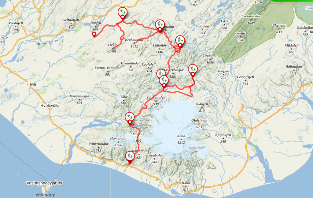
The journey begins at Skógar on Iceland’s south coast and crosses Fimmvörðuháls into Þórsmörk before continuing north toward Hvanngil.
From Hvanngil, the route leaves the classic Laugavegur corridor and continues toward Mælifell, one of the places I was unable to reach on my previous trip. From there, I plan to continue through Strútslaug and Álfavatn before reaching Landmannalaugar.
I plan to spend an additional day in Landmannalaugar to explore several trails I did not have time to hike last year. The route then continues to Landmannahellir, where I also plan to stay an extra day and hike Krakatindur.
From Landmannahellir, I will continue toward Áfangagil and finally Rjúpnavellir. If weather and conditions allow, I would also like to include a summit attempt on Hekla as part of the final section of the journey.
The complete route will combine established trails with quieter and more remote sections of the Highlands, crossing volcanic deserts, geothermal areas, mountain valleys and several unbridged rivers. Daily distances and the exact itinerary will remain flexible, with weather, river levels and terrain conditions ultimately determining the pace of the journey.
Skógar → Þórsmörk → Hvanngil → Mælifell → Strútslaug → Álfavatn → Landmannalaugar → Landmannahellir → Áfangagil → Rjúpnavellir
Optional: Hekla summit, weather permitting
Expedition Goals
The primary goal of Beyond the Laugavegur is to complete my first long-distance, multi-day solo trek and find out how I handle being fully responsible for myself over many consecutive days in the Highlands. Beyond completing the route itself, I want to develop the skills that will become increasingly important on future expeditions — endurance, navigation, camp routines, equipment management, river crossings, decision-making and adapting the plan when conditions change.
Documenting the Highlands
Throughout the journey, I want to document the Icelandic Highlands as I experience them on foot. I am particularly interested in the dramatic changes in geology and landscape along the route, as well as the way weather, rivers and rapidly changing conditions shape both the environment and the journey through it.
Whenever clear skies allow, I also plan to continue my aurora observations. I want to photograph and document different forms of auroral activity and compare what I observe with available space-weather data such as IMF Bz and Bt, solar wind speed and geomagnetic activity.
Revisiting Places & Exploring New Ones
Part of this journey is also about returning to places that made me want to explore the Highlands further. I want to spend more time around Landmannalaugar and Landmannahellir, revisit landscapes I discovered last year and hike routes I did not have time or abilities to explore.
The route will also allow me to complete the first section of the Laugavegur between Þórsmörk and Álftavatn, include Mælifell and explore more of the Hellismannaleið area, including Krakatindur. I also hope to include a summit of Hekla, if the weather permits.
Sharing the Journey
A major goal of the expedition is to turn the experience into something I can share with others. I plan to document the journey through photography, video and written field notes, while also sharing practical experience, route information and travel tips for people interested in exploring the Icelandic Highlands independently.
The expedition will become the basis for a YouTube documentary, following the journey from preparation to the final kilometres and showing both the extraordinary landscapes and the reality behind a solo long-distance trek. I also plan to publish detailed stories and practical content on Frozen Redhead and through my social media channels.